It's been a while. Took a leasuirely stroll in a southern NH state park with my Siamese Dreamer.
History:
Peak Elevation: 908ft
Elevation Gain: laughable, a few hundred feet?
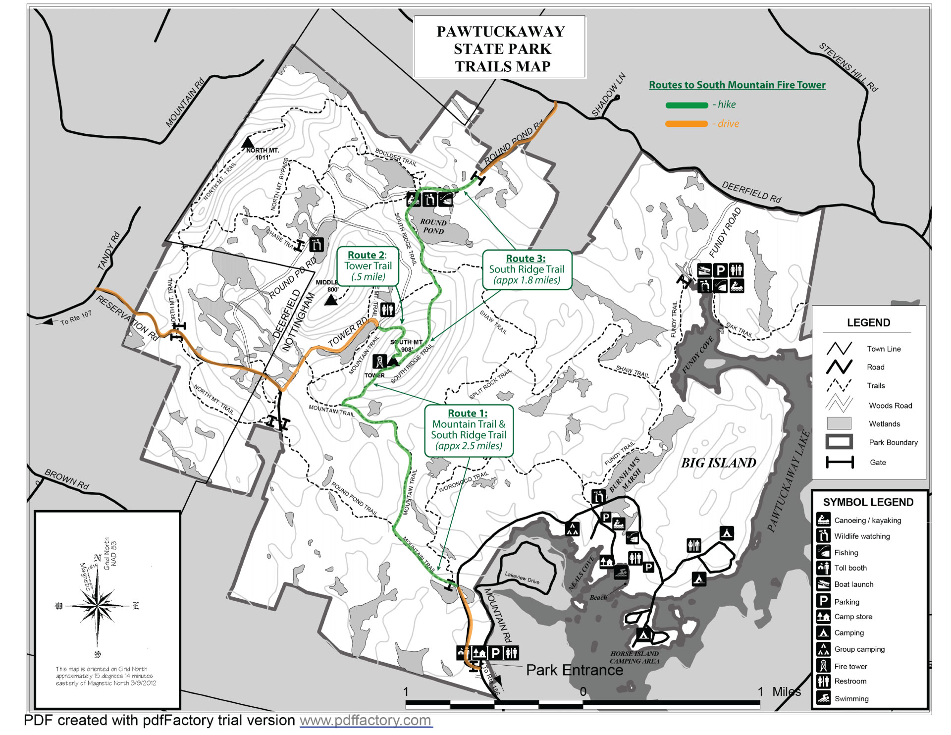
Trail: Roadway, Mountain Trail, South Ridge Trail
Length: 6.5ish miles
Time on Trail: 1130
Time off Trail: 1455
I wanted to take a hike with my lady, Ms. Siamese Dreamer. We intended to do something on 52WAV but slept in and made the best of a gorgeous day. Parked at the Visitors center and hoofed the half mile or so to the Mountain Trail trailhead, and crushed our way up a few hundred feet of elevation gain. We reached the tower there at about 1300, and that was pretty neat. not much else to say on this one, a good day to dust off and get outside.
Hotlinked map image of the trails taken:
Photos:
https://imgur.com/a/kvci4if
Optional closing thought
An account of one man's hike through NH's 4000 footers and beyond - all without wearing pants.
Showing posts with label Firetower Quest. Show all posts
Monday, April 19, 2021
Sunday, April 15, 2018
2018 goals and plans
So over the past few months i have been backdating entries as my time allows - i usually do it in marathon sessions which involves some research that i do not have up front, which occupies about half the time spent. Given that this blog was started in 2017, as my season was crawling to its close, I didn't do anything like this before. So bear with me if it seems scatterbrained. My goals for hiking this year are as follows: 15 peaks from 52 WAV list, 12 peaks from NH48, and 3 or 4 from the NE67 that reside outside of NH. Here's an early projection of what my approximate plan is:
52 WAV hikes:
- Mt Crawford, Mt Resolution, Stairs Mountain 11.2 mi
- Magalloway Mountain
- Mt Hayes
- Sugarloaf Mountain (Nash Stream Forest) 4.2 mi
- Mt Shelburne Moriah
- Mt Success
- Three Sisters
- Shaw
- North and South Baldface
- Eastman
- North Doublehead
- Smarts
- West Royce
NH48 Hikes:
- West Bond, Mt Bond, Bondcliff, Zealand 19ish mi
- North and South Twin 11ish mi.
- Wildcat D, Wildcat A
- Madison and Adams 10.1 mi
- North and South Kinsman
Non-NH28 peaks from NE67:
- Katahdin (ME14) looking to do this around Septemberish
- Killington (VT5)
- Mt. Abraham (VT5)
- Mt. Ellen (VT5)
To date, i have 30/48, 30/67 and 20/52.
I hope to continue hiking with BTLG, Bishop X and some old and new work friends this year, but will never back down from doing any of these as a solo venture.
I'll probably make some edits to this with mileages and intended trails for my own tracking purposes.
52 WAV hikes:
- Mt Crawford, Mt Resolution, Stairs Mountain 11.2 mi
- Magalloway Mountain
- Mt Hayes
- Sugarloaf Mountain (Nash Stream Forest) 4.2 mi
- Mt Shelburne Moriah
- Mt Success
- Three Sisters
- Shaw
- North and South Baldface
- Eastman
- North Doublehead
- Smarts
- West Royce
NH48 Hikes:
- West Bond, Mt Bond, Bondcliff, Zealand 19ish mi
- North and South Twin 11ish mi.
- Wildcat D, Wildcat A
- Madison and Adams 10.1 mi
- North and South Kinsman
Non-NH28 peaks from NE67:
- Katahdin (ME14) looking to do this around Septemberish
- Killington (VT5)
- Mt. Abraham (VT5)
- Mt. Ellen (VT5)
To date, i have 30/48, 30/67 and 20/52.
I hope to continue hiking with BTLG, Bishop X and some old and new work friends this year, but will never back down from doing any of these as a solo venture.
I'll probably make some edits to this with mileages and intended trails for my own tracking purposes.
Labels:
52wav,
Appalachain Trail,
Firetower Quest,
ME14,
NE67,
NH48,
VT5
Location:
Hooksett, NH, USA
Tuesday, October 3, 2017
03 October 2017: Mount Cardigan (and Rimrock, South Peak)
This was my second time out with my friend from work, "Zoey", and her dog LOGAN. Logan is a handful and today he had a ball as we explored Mount Cardigan. This is one I will gladly do time and time again, and I would love to try all of the trails up this gem.
History: Cardigan Mountain resides within a state park bearing it's name, this peak offers many things to a vairety of people. The geology of the mountain is notable, as is the network of alpine ski trails in it's shadow on the eastern slopes. Those ski trails were developed by the Civilian Conservation Corps. The summit saw a rather devastating forest fire back in the 1850s and has never truly recovered. The AMC has a lodge on the eastern side of the mountain, making it a popular destination for hikers to set up as a base camp for day hikes.
Peak Elevation: 3156 ft
Elevation Gain: 1100 ft (est)
Trail: West Ridge Trail, South Slide Trail, Skyland Trail
Length: 5.5 mi
Time on Trail : 1000ish
Time off Trail: 1300ish
This was Zoey and I's second hike out - we wanted something quick and fun and Cardigan definitely hit the nail on the head. My friend and her BF are working on the NH48 as well and any hiking to keep fitness up for either of us was a welcome challenge. I was aiming to bag a bunch of of the 52WAV peaks this fall as well. I had intended to advise we try the other side's trails so we could go to Firescrew Mountain, but I had a brainfart on the drive up and we ended up closer to Orange NH. I didn't really care that much about what we did as long as we got out on the trails! Firescrew, I'll be back for you.
West rim trail was pretty easy to get to, parking there is ample (state park fees apply) and the West Ridge Trailhead even has composting toilets for those who need such a thing. The trail offers pretty easy grading for most of the way. It's the most direct way up the mountain peak as well, which comes in handy for weather related rapid descents. We decided that because the mileage was short we could explore the south peak and rimrock as well. We found some of the buildings along the way which are either for nordic skiers or fire wardens, maybe? Or maybe they're something you can reserve? I'll have to do some digging later.
The peak is balder than I am, and offers panoramic views. The fire tower was not open and did not appear to be occupied while we were there. When we arrived we only saw a few other people. LOGAN made a friend who chased him the entire time. The other dog's owner was pretty nice, and I think she thought my friend and I were an item, which was kind of awkward (for me anyhow).
We descended straight down West Ridge Trail at the end of the day. The blazes are clearly marked and I have no complaints about the condition of anything here. It was a remarkably stellar day outside. And I didn't burn too badly!
Photos:
Link to useful info about Hiking Cardigan: https://www.nhstateparks.org/visit/state-parks/Cardigan-Mountain-State-Park.aspx
History: Cardigan Mountain resides within a state park bearing it's name, this peak offers many things to a vairety of people. The geology of the mountain is notable, as is the network of alpine ski trails in it's shadow on the eastern slopes. Those ski trails were developed by the Civilian Conservation Corps. The summit saw a rather devastating forest fire back in the 1850s and has never truly recovered. The AMC has a lodge on the eastern side of the mountain, making it a popular destination for hikers to set up as a base camp for day hikes.
Peak Elevation: 3156 ft
Elevation Gain: 1100 ft (est)
Trail: West Ridge Trail, South Slide Trail, Skyland Trail
Length: 5.5 mi
Time on Trail : 1000ish
Time off Trail: 1300ish
This was Zoey and I's second hike out - we wanted something quick and fun and Cardigan definitely hit the nail on the head. My friend and her BF are working on the NH48 as well and any hiking to keep fitness up for either of us was a welcome challenge. I was aiming to bag a bunch of of the 52WAV peaks this fall as well. I had intended to advise we try the other side's trails so we could go to Firescrew Mountain, but I had a brainfart on the drive up and we ended up closer to Orange NH. I didn't really care that much about what we did as long as we got out on the trails! Firescrew, I'll be back for you.
West rim trail was pretty easy to get to, parking there is ample (state park fees apply) and the West Ridge Trailhead even has composting toilets for those who need such a thing. The trail offers pretty easy grading for most of the way. It's the most direct way up the mountain peak as well, which comes in handy for weather related rapid descents. We decided that because the mileage was short we could explore the south peak and rimrock as well. We found some of the buildings along the way which are either for nordic skiers or fire wardens, maybe? Or maybe they're something you can reserve? I'll have to do some digging later.
The peak is balder than I am, and offers panoramic views. The fire tower was not open and did not appear to be occupied while we were there. When we arrived we only saw a few other people. LOGAN made a friend who chased him the entire time. The other dog's owner was pretty nice, and I think she thought my friend and I were an item, which was kind of awkward (for me anyhow).
We descended straight down West Ridge Trail at the end of the day. The blazes are clearly marked and I have no complaints about the condition of anything here. It was a remarkably stellar day outside. And I didn't burn too badly!
Photos:
Mt Cardigan (Including Rimrock and South peak) 03OCT17Link to useful info about Hiking Cardigan: https://www.nhstateparks.org/visit/state-parks/Cardigan-Mountain-State-Park.aspx
Labels:
52wav,
Firetower Quest,
New England Fifty Finest
Location:
Mt Cardigan, Orange, NH 03741, USA
Subscribe to:
Posts (Atom)